Solar PV Analysis of Glenolden, United States
Glenolden, Pennsylvania, in the United States is a location with moderate potential for solar energy generation throughout the year. Located in the Northern Temperate Zone, this area experiences significant seasonal variations in solar production.
Seasonal Solar Production
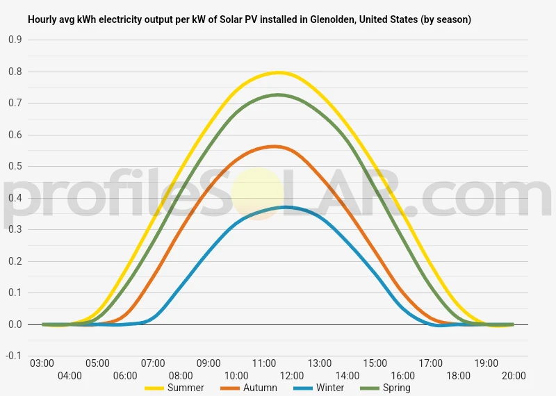
Solar panels in Glenolden perform best during summer months, generating approximately 6.45kWh per day for each kilowatt of installed capacity. Spring follows as the second most productive season with 5.58kWh/day per kW. Production drops considerably in autumn to 3.73kWh/day, and reaches its lowest point in winter with only 2.25kWh/day per kW of installed capacity.
This pattern creates a substantial difference between peak summer production and winter lows, with summer generating nearly three times the electricity of winter months. The shoulder seasons of spring and autumn serve as transitional periods, with spring being notably more productive than fall.
Optimal Panel Installation
For fixed solar panel installations in Glenolden, the ideal tilt angle to maximize year-round energy production is 34 degrees facing South. This angle provides the best compromise between capturing low-angle winter sunlight and the more direct summer sun, optimizing total annual energy yield.
Environmental and Weather Considerations
Several factors may impact solar production in Glenolden that prospective solar adopters should consider:
- Snow accumulation during winter months can temporarily reduce or eliminate production until panels clear
- Tree cover and building shadows may be significant in this suburban area
- Moderate to high humidity levels in summer can slightly reduce panel efficiency
- Occasional cloudy weather patterns typical of the Mid-Atlantic region
To mitigate these challenges, installations should include snow-shedding mounting systems with adequate tilt to help panels clear more quickly after snowfall. Careful site assessment for shade patterns throughout the year is essential. Panel placement should avoid areas where trees or structures cast shadows, particularly during peak production hours. Regular cleaning may be necessary to remove pollen in spring and other debris that can accumulate on panels.
While not ideal year-round due to the significant winter production drop, Glenolden still offers sufficient solar resources to make photovoltaic systems economically viable, especially when designed with these seasonal variations in mind.
Note: The Northern Temperate Zone extends from 35° latitude North up to 66.5° latitude.
So far, we have conducted calculations to evaluate the solar photovoltaic (PV) potential in 4253 locations across the United States. This analysis provides insights into each city/location's potential for harnessing solar energy through PV installations.
Link: Solar PV potential in the United States by location
Solar output per kW of installed solar PV by season in Glenolden
Seasonal solar PV output for Latitude: 39.9022, Longitude: -75.2942 (Glenolden, United States), based on our analysis of 8760 hourly intervals of solar and meteorological data (one whole year) retrieved for that set of coordinates/location from NASA POWER (The Prediction of Worldwide Energy Resources) API:




Ideally tilt fixed solar panels 34° South in Glenolden, United States
To maximize your solar PV system's energy output in Glenolden, United States (Lat/Long 39.9022, -75.2942) throughout the year, you should tilt your panels at an angle of 34° South for fixed panel installations.
As the Earth revolves around the Sun each year, the maximum angle of elevation of the Sun varies by +/- 23.45 degrees from its equinox elevation angle for a particular latitude. Finding the exact optimal angle to maximise solar PV production throughout the year can be challenging, but with careful consideration of historical solar energy and meteorological data for a certain location, it can be done precisely.
We use our own calculation, which incorporates NASA solar and meteorological data for the exact Lat/Long coordinates, to determine the ideal tilt angle of a solar panel that will yield maximum annual solar output. We calculate the optimal angle for each day of the year, taking into account its contribution to the yearly total PV potential at that specific location.

Seasonally adjusted solar panel tilt angles for Glenolden, United States
If you can adjust the tilt angle of your solar PV panels, please refer to the seasonal tilt angles below for optimal solar energy production in Glenolden, United States. As mentioned earlier, for fixed-panel solar PV installations, it is optimal to maintain a 34° South tilt angle throughout the year.
| Overall Best Summer Angle | Overall Best Autumn Angle | Overall Best Winter Angle | Overall Best Spring Angle |
|---|---|---|---|
| 23° South in Summer | 44° South in Autumn | 55° South in Winter | 33° South in Spring |
Our recommendations take into account more than just latitude and Earth's position in its elliptical orbit around the Sun. We also incorporate historical solar and meteorological data from NASA's Prediction of Worldwide Energy Resources (POWER) API to assign a weight to each ideal angle for each day based on its historical contribution to overall solar PV potential during a specific season.
This approach allows us to provide much more accurate recommendations than relying solely on latitude, as it considers unique weather conditions in different locations sharing the same latitude worldwide.
Calculate solar panel row spacing in Glenolden, United States
We've added a feature to calculate minimum solar panel row spacing by location. Enter your panel size and orientation below to get the minimum spacing in Glenolden, United States.
Our calculation method
- Solar Position:
We determine the Sun's position on the Winter solstice using the location's latitude and solar declination. - Shadow Projection:
We calculate the shadow length cast by panels using trigonometry, considering panel tilt and the Sun's elevation angle. - Minimum Spacing:
We add the shadow length to the horizontal space occupied by tilted panels.
This approach ensures maximum space efficiency while avoiding shading during critical times, as the Winter solstice represents the worst-case scenario for shadow length.
Topography for solar PV around Glenolden, United States
Glenolden, Pennsylvania is situated in Delaware County in the southeastern region of Pennsylvania, approximately 8 miles southwest of Philadelphia. The topography of Glenolden and its surrounding areas is characterized by gently rolling terrain typical of the Atlantic Coastal Plain physiographic province, with some areas transitioning into the slightly more elevated Piedmont region to the west. The landscape around Glenolden features modest elevation changes, with the terrain generally sloping downward from west to east toward the Delaware River. The area has an average elevation of approximately 80 feet (24 meters) above sea level, with minimal dramatic relief features. The local topography has been significantly influenced by the numerous waterways that traverse the region, including Darby Creek, which flows near Glenolden and eventually empties into the Delaware River.
Surrounding Landscape Features
The immediate vicinity around Glenolden consists of suburban development interspersed with small patches of woodlands and open spaces. To the east, the terrain gradually descends toward the Delaware River and its associated wetlands and floodplains. Moving westward, the landscape begins to show more pronounced rolling hills as it transitions toward the Piedmont region. Notable nearby topographical features include the John Heinz National Wildlife Refuge at Tinicum, located a few miles to the east, which encompasses the largest remaining freshwater tidal marsh in Pennsylvania. This low-lying area contrasts with the slightly more elevated terrain found to the northwest in areas like Springfield and Swarthmore.Potential Areas for Solar PV Development
When considering large-scale solar photovoltaic (PV) installations near Glenolden, several factors related to topography become important. The most suitable areas would generally include: The relatively flat industrial zones along the Delaware River corridor, particularly in areas like Chester, Marcus Hook, and portions of Southwest Philadelphia offer substantial open spaces with minimal shading concerns. These post-industrial landscapes often feature brownfield sites that could be repurposed for solar energy production. Former landfill sites in the region, such as those in Upper Darby and Folcroft, present opportunities for solar development on land with limited alternative uses. Their elevated profiles often create favorable conditions for solar exposure with minimal obstruction. The agricultural and open spaces found further west in Delaware County and into Chester County provide larger continuous tracts of land with favorable topography for solar arrays. These areas feature gently rolling terrain that can be adapted for solar installations without extensive grading. Areas to avoid would include the more densely forested sections of the Piedmont region to the northwest, where clearing would be environmentally disruptive, and the wetland areas to the east, which serve important ecological functions and are subject to flooding. The moderately sloped areas throughout Delaware County generally face south, southeast, or southwest, which is advantageous for solar energy collection. However, the suburban nature of much of the immediate surroundings of Glenolden means that truly large-scale solar development would likely need to occur in the more open areas to the southwest along the Delaware River industrial corridor or to the west where larger tracts of land are available.United States solar PV Stats as a country
United States ranks 2nd in the world for cumulative solar PV capacity, with 95,209 total MW's of solar PV installed. This means that 3.40% of United States's total energy as a country comes from solar PV (that's 26th in the world). Each year United States is generating 289 Watts from solar PV per capita (United States ranks 15th in the world for solar PV Watts generated per capita). [source]
Are there incentives for businesses to install solar in United States?
Yes, there are several incentives for businesses wanting to install solar energy in the United States. These include federal tax credits, state and local rebates, net metering policies, and renewable energy certificates (RECs). Additionally, many states have enacted legislation that requires utilities to purchase a certain amount of electricity from renewable sources such as solar.
Do you have more up to date information than this on incentives towards solar PV projects in United States? Please reach out to us and help us keep this information current. Thanks!
Citation Guide
Article Details for Citation
Author: Aaron Robinson
Publisher: profileSOLAR.com
First Published: Monday 5th of May 2025
Last Updated: Tuesday 30th of September 2025
Tell Us About Your Work
We love seeing how our research helps others! If you've cited this article in your work, we'd be delighted to hear about it. Drop us a line via our Contact Us page or on X, to share where you've used our information - we may feature a link to your work on our site. This helps create a network of valuable resources for others in the solar energy community and helps us understand how our research is contributing to the field. Plus, we occasionally highlight exceptional works that reference our research on our social media channels.
Feeling generous?

Share this with your friends!


Compare this location to others worldwide for solar PV potential
The solar PV analyses available on our website, including this one, are offered as a free service to the global community. Our aim is to provide education and aid informed decision-making regarding solar PV installations.
However, please note that these analyses are general guidance and may not meet specific project requirements. For in-depth, tailored forecasts and analysis crucial for feasibility studies or when pursuing maximum ROI from your solar projects, feel free to contact us; we offer comprehensive consulting services expressly for this purpose.

Helping you assess viability of solar PV for your site
Calculate Your Optimal Solar Panel Tilt Angle: A Comprehensive Guide
Enhance your solar panel's performance with our in-depth guide. Determine the best tilt angle using hard data, debunk common misunderstandings, and gain insight into how your specific location affects solar energy production.