 Solar PV Analysis of Bongabong, Philippines
Solar Energy Potential in Bongabong, Mimaropa, Philippines
Bongabong, Mimaropa, Philippines offers a promising location for solar energy generation, with consistent sunlight throughout the year typical of its tropical climate. This coastal municipality in Oriental Mindoro receives substantial solar radiation that can be effectively harnessed for electricity production via photovoltaic (PV) systems. The solar energy generation potential varies across seasons, with spring showing the highest productivity at 6.68 kWh per day for each kilowatt of installed capacity. Summer follows with 5.43 kWh/day, while autumn and winter produce 5.01 kWh/day and 4.80 kWh/day respectively. This seasonal variation demonstrates that while Bongabong experiences some fluctuation in solar potential, it maintains relatively strong production capabilities throughout the year. For maximum energy capture with fixed solar panel installations in Bongabong, Mimaropa, panels should be tilted at 11 degrees facing South. This specific angle has been calculated to optimize year-round solar energy collection based on the location's latitude and solar path patterns.Environmental and Weather Considerations
Several significant factors could affect solar production in Bongabong:- Typhoons and tropical cyclones that frequently affect the Philippines, particularly during the wet season (May to October), can damage solar installations and reduce efficiency
- Heavy rainfall during the monsoon season can decrease solar output through cloud cover and direct panel soiling
- High humidity levels can lead to condensation on panels, potentially reducing efficiency
- Salt spray exposure due to the coastal location may accelerate corrosion of system components
Note: The Tropics are located between 23.5° North and -23.5° South of the equator.
So far, we have conducted calculations to evaluate the solar photovoltaic (PV) potential in 268 locations across Philippines. This analysis provides insights into each city/location's potential for harnessing solar energy through PV installations.
Link: Solar PV potential in Philippines by location
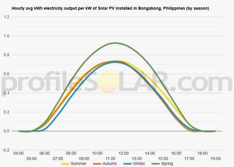
Solar output per kW of installed solar PV by season in Bongabong
Seasonal solar PV output for Latitude: 12.744, Longitude: 121.4904 (Bongabong, Philippines), based on our analysis of 8760 hourly intervals of solar and meteorological data (one whole year) retrieved for that set of coordinates/location from NASA POWER (The Prediction of Worldwide Energy Resources) API:




Ideally tilt fixed solar panels 11° South in Bongabong, Philippines
To maximize your solar PV system's energy output in Bongabong, Philippines (Lat/Long 12.744, 121.4904) throughout the year, you should tilt your panels at an angle of 11° South for fixed panel installations.
As the Earth revolves around the Sun each year, the maximum angle of elevation of the Sun varies by +/- 23.45 degrees from its equinox elevation angle for a particular latitude. Finding the exact optimal angle to maximise solar PV production throughout the year can be challenging, but with careful consideration of historical solar energy and meteorological data for a certain location, it can be done precisely.
We use our own calculation, which incorporates NASA solar and meteorological data for the exact Lat/Long coordinates, to determine the ideal tilt angle of a solar panel that will yield maximum annual solar output. We calculate the optimal angle for each day of the year, taking into account its contribution to the yearly total PV potential at that specific location.

Seasonally adjusted solar panel tilt angles for Bongabong, Philippines
If you can adjust the tilt angle of your solar PV panels, please refer to the seasonal tilt angles below for optimal solar energy production in Bongabong, Philippines. As mentioned earlier, for fixed-panel solar PV installations, it is optimal to maintain a 11° South tilt angle throughout the year.
| Overall Best Summer Angle | Overall Best Autumn Angle | Overall Best Winter Angle | Overall Best Spring Angle |
|---|---|---|---|
| 3° North in Summer | 19° South in Autumn | 28° South in Winter | 6° South in Spring |
Our recommendations take into account more than just latitude and Earth's position in its elliptical orbit around the Sun. We also incorporate historical solar and meteorological data from NASA's Prediction of Worldwide Energy Resources (POWER) API to assign a weight to each ideal angle for each day based on its historical contribution to overall solar PV potential during a specific season.
This approach allows us to provide much more accurate recommendations than relying solely on latitude, as it considers unique weather conditions in different locations sharing the same latitude worldwide.
Calculate solar panel row spacing in Bongabong, Philippines
We've added a feature to calculate minimum solar panel row spacing by location. Enter your panel size and orientation below to get the minimum spacing in Bongabong, Philippines.
Our calculation method
- Solar Position:
We determine the Sun's position on the Winter solstice using the location's latitude and solar declination. - Shadow Projection:
We calculate the shadow length cast by panels using trigonometry, considering panel tilt and the Sun's elevation angle. - Minimum Spacing:
We add the shadow length to the horizontal space occupied by tilted panels.
This approach ensures maximum space efficiency while avoiding shading during critical times, as the Winter solstice represents the worst-case scenario for shadow length.
Topography for solar PV around Bongabong, Philippines
Bongabong is situated in the eastern part of Mindoro Island in the Philippines, with a diverse topographical landscape that transitions from coastal plains to mountainous terrain. The municipality extends from the shores of the Sibuyan Sea to the inland mountain ranges that form the backbone of Oriental Mindoro province.
Coastal Plains and River Valleys
The eastern portion of Bongabong features relatively flat coastal plains that gradually rise as one moves inland. These lowland areas are characterized by fertile soil, with numerous rivers and streams flowing from the mountains toward the sea. The Bongabong River is a significant waterway that traverses the municipality, creating alluvial plains that have historically been utilized for agriculture, particularly rice cultivation.Rolling Hills and Foothills
Moving westward from the coast, the landscape transitions into gently rolling hills and foothills. This intermediate zone features undulating terrain with moderate slopes and elevations typically ranging from 50 to 200 meters above sea level. These areas often contain a mix of agricultural land, grasslands, and secondary forests.Mountainous Interior
The western portions of Bongabong rise into the mountainous interior of Mindoro Island. This region is part of the central mountain range that runs north-south through the island. Elevations in these areas can exceed 1,000 meters above sea level, with steep slopes, deep valleys, and forested terrain. These mountains form part of the watershed that supplies the municipality's river systems.Potential Areas for Solar PV Development
For large-scale solar photovoltaic installations, the most suitable areas within and around Bongabong would be the gently sloping terrain of the foothills and certain portions of the coastal plains that are not prone to flooding or reserved for agricultural production. The rolling hills located 3-10 kilometers inland from the coast offer particularly promising conditions for solar development. These areas typically have: - Sufficient elevation to avoid coastal flooding concerns - Gentle slopes that minimize the need for extensive land grading - Reduced agricultural value compared to the fertile river valleys - Good exposure to sunlight with minimal shadowing from the more distant mountain ranges Specifically, the elevated terrain between the barangays of Labasan, Masaguisi, and Mapang presents favorable topography for solar installations. These areas are high enough to avoid most flooding concerns while remaining accessible via existing road networks. Areas to avoid would include the steeper mountain slopes in the western portions of the municipality, where construction would be challenging and environmental impacts more severe, as well as the prime agricultural lands along the river valleys, where food security considerations may outweigh energy production benefits. The northeastern portions of Bongabong, where the terrain begins to rise from the coastal plain but remains relatively gentle, represent a good compromise between accessibility, suitable topography, and minimal conflict with other land uses.Philippines solar PV Stats as a country
Philippines ranks 40th in the world for cumulative solar PV capacity, with 1,370 total MW's of solar PV installed. Each year Philippines is generating 13 Watts from solar PV per capita (Philippines ranks 71st in the world for solar PV Watts generated per capita). [source]
Are there incentives for businesses to install solar in Philippines?
Yes, there are several incentives for businesses wanting to install solar energy in the Philippines. These include:
1. The Feed-in Tariff (FiT) program, which provides a guaranteed rate of return on investments in renewable energy projects;
2. Tax credits and exemptions from certain taxes;
3. Net metering programs that allow businesses to sell excess electricity back to the grid;
4. Grants and loans from government agencies such as the Department of Energy and the Philippine Solar Power Alliance;
5. Technical assistance from organizations like USAID’s Clean Energy Program; and
6. Access to financing through banks, venture capital firms, or other sources of private capital.
Do you have more up to date information than this on incentives towards solar PV projects in Philippines? Please reach out to us and help us keep this information current. Thanks!
Citation Guide
Article Details for Citation
Author: Aaron Robinson
Publisher: profileSOLAR.com
First Published: Monday 21st of April 2025
Last Updated: Monday 1st of September 2025
Tell Us About Your Work
We love seeing how our research helps others! If you've cited this article in your work, we'd be delighted to hear about it. Drop us a line via our Contact Us page or on X, to share where you've used our information - we may feature a link to your work on our site. This helps create a network of valuable resources for others in the solar energy community and helps us understand how our research is contributing to the field. Plus, we occasionally highlight exceptional works that reference our research on our social media channels.
Feeling generous?

Share this with your friends!


Compare this location to others worldwide for solar PV potential
The solar PV analyses available on our website, including this one, are offered as a free service to the global community. Our aim is to provide education and aid informed decision-making regarding solar PV installations.
However, please note that these analyses are general guidance and may not meet specific project requirements. For in-depth, tailored forecasts and analysis crucial for feasibility studies or when pursuing maximum ROI from your solar projects, feel free to contact us; we offer comprehensive consulting services expressly for this purpose.

Helping you assess viability of solar PV for your site
Calculate Your Optimal Solar Panel Tilt Angle: A Comprehensive Guide
Enhance your solar panel's performance with our in-depth guide. Determine the best tilt angle using hard data, debunk common misunderstandings, and gain insight into how your specific location affects solar energy production.